
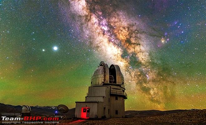
 Hanle (also spelt Anle) is a large historic village in the Indian union territory of Ladakh. It is the site of the 17th century Hanle Monastery. (gompa) of the Drukpa Kagyu branch of Tibetan Buddhism. Hanle is located in the Hanle River valley on an old branch of the ancient Ladakh-Tibet trade route. More recently, Hanle is the home of Hanle Observatory, one of the world's highest sites for astronomical observatory
Geography
Hanle is in the valley of the Hanle River, which originates near the Imis La pass on the border with Tibet and joins the Indus river at Loma, close to the town of Nyoma. A road running through the Hanle valley from Loma is the quickest way to reach Hanle. Though the road terminates near Hanle, the traditional trade and pilgrimage corridor formerly ran up the Hanle valley to Imis La, crossed into the Indus valley via Charding La near Demchok and Demgog, and proceeded to Tashigang in Tibet. This corridor using Tibetan territory is now closed.
Hanle is also connected to Koyul river Valley to the east via a winding mountain road that passes through the Photi La pass.
Demographics
The valley is home to approximately two thousand people, of whom about 300 people are living in Hanle village.
History
Hanle is mentioned by name in the settlement document of the kingdom of Maryul in c. 930 AD, as forming one of its frontiers: "Wam-le (Hanle), to the top of the pass of the Yi-mig rock (Imis pass)". To the west of this frontier were the highlands of Rupshu and, beyond it, Zanskar.
Sengge Namgyal (r. 1616–1642) built the prominent Hanle monastery in association with Stag-tsang-ras-pa, the notable Buddhist priest of the Drukpa ("red hat") sect. Sengge Namgyal died here in 1642 after his return from an expedition against the Mongols who had occupied the Tibetan province of Tsang and were threatening Ladakh.
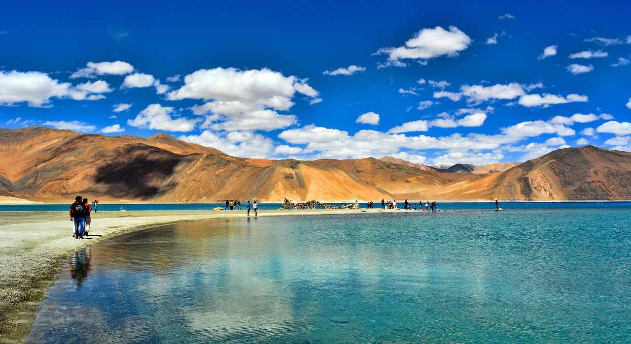 Pangong Tso is one of the largest brackish lakes in Asia. Stretching from eastern Ladakh to Tibet, it is a 134 kilometer long narrow strip of water where tourist needs an Inner Line Permit to visit. It is nestled at an elevation of 14,256 feet above sea level and freezes completely during the winters. Currently, it is in the process of being recognized as a globally much-admired wetland under the Ramsar Convention. The saltwater of this lake has very sparse vegetation and is bereft of any aquatic life except for little crustaceans. Pangong Lake is a paradise for bird watchers as it plays important role as a main breeding point for a number of migrant birds like Brahmini ducks and Bar-headed goose.
Pangong is an endorheic lake in the ladakh, nestled at an elevation of around 14,270 feet. Around 60% portion of the lake lies in China. To access the Pangong Lake, tourists can take a five hours long drive from Leh through coarse and dramatic mountain road. Pangong Tso is a average terrain. The Line of Actual Control passes through this lake. The 20 kilometers east of this lake from the Line of Actual Control is controlled by China and its eastern end lies in Tibet. Located on the northern bank of the Pangong Lake, the Khurnak Fort is located midway of Pangong Tso. By the end of 1952, the Chinese military controlled the Khurnak Fort area.
 Turtuk: Turtuk is a small village located in Nubra Valley region of Ladakh, on the banks of Shyok River. It is the northernmost villages in India lying very close to the India Pakistan border, in the Baltistan region. Turtuk is an unexplored and offbeat place, opened to tourists only in 2010. There isn't much to do in Turtuk apart from trekking and visiting the 2 monasteries and the Royal House. The picturesque village with its tiny houses and fields is surreal. It remains cut off from Ladakh for 6 months during winter. The charm of Turtuk is its people and culture. It is one of the few places in India to experience the Balti culture as Turtuk is one of the four Baltistani villages under India's control. The rest are controlled by Pakistan. The postcard village houses a few homestays and guesthouses with locals welcoming tourists with warmth.
 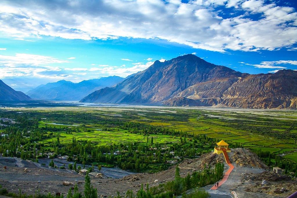 The original name used for Nubra Valley is Ldumra meaning the 'valley of flowers' It is situated in the north of Ladakh region. The average altitude of the valley is about 10,000 mtrs above sea level. The main settlements are along the shayok River and the siachen river. The river belt is sandy and the vegetation includes green Farmarisk and Myricaria. One of the unique features of the landscapes in Nubra is the sand dunes between Diskit (administrative center) Hundar villages.
An ancient trade route (a branch of the popular Central Asian silk route) used to pass through Nubra Valley and its imprints can be seen even today. The double humped Bactrian Camels of the silk route trade period still wander in the wilderness of the valley. Tourists require permits from the local administration in leh for a stay of maximum seven days in this strategically sensitive area. Six photocopies of the permit should be carried along by you to be submitted at the various check posts on the way.
 Zanskar lies to the south-west of leh, surrounded by the Himalayan and zanskar ranges, which is the most isolated of all the trans-himalayan valley. It takes two days, with a nigh halt at kargil, to reach Zanskar negotiating the rough road beginning from kargil.
Zanskar comprise two main valleys of stod (Doda chu) and lungnak (Tsarab chu)(, which converge below at padum. The valley has an area of about 5,000 square km and an elevation of 13,154 ft. the area remains inaccessible for nearly 7 months in the year. All the high passes gets closed in winters. The only alternate route out of Zanskar river, which has become a popular destiny for winter tourist hikers.it is nearly week long walk on frozen river from Zanskar to reach leh. This is popular as chadar trek.
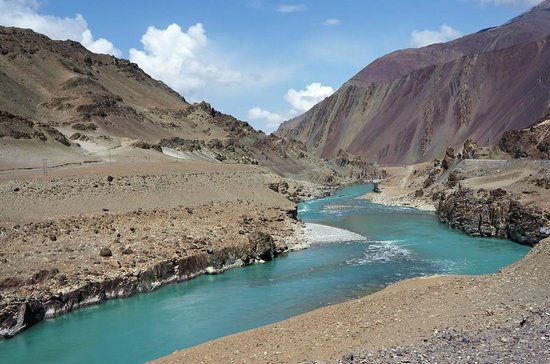
 Sangam: Sangam is the confluence of Indus and Zanskar Rivers in Ladakh. It is located 35km from Leh in Nimmu, on the Leh Srinagar highway. The two rivers can be separately seen meeting at this point. While the Indus River appears as shiny blue, Zanskar River appears muddy green. It is a spectacular site to witness. The flow of the two rivers at Sangam changes according to the season. While Zanskar River is swollen and rapis in summers, Indus River is calmer. In winters, Zanskar slows down and almost freezes while the flow of Indus is even lesser. The Indus is the one of the longest rivers in Asia and originates in Tibet. Zanskar River is formed in the Zanskar Valley region.
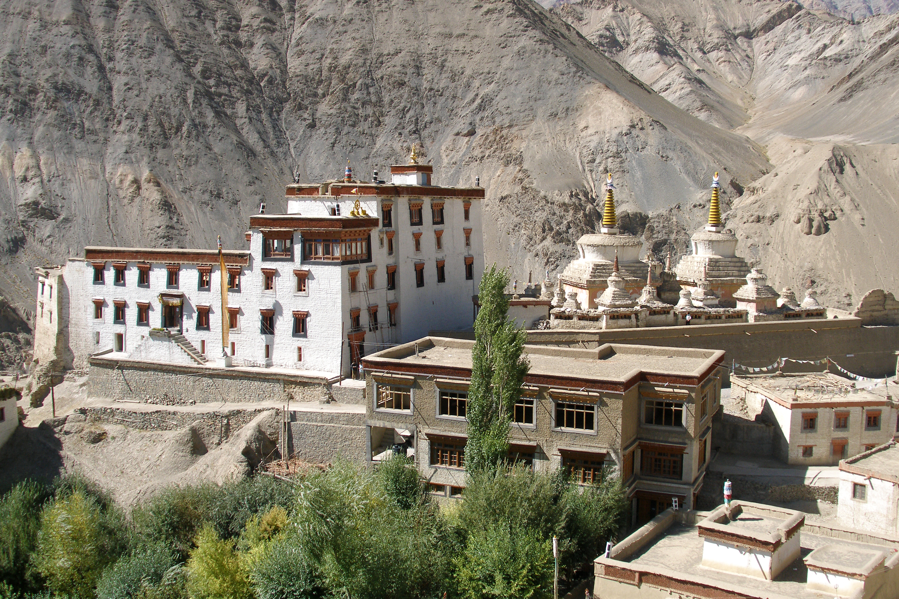 Lamayuru is on the Leh – Srinagar Highway, and can be visited from Leh (if you fly in) or on your way from Srinagar if you drive to Leh.
Lamayuru monastery is situated at a distance of 127 KM from Leh at a height of 3,510 meters. Lamayuru can easily be covered in a day return trip from Leh. Lamayuru is known for its monastery, and for its “lunar” landscape – quaintly promoted as a “Moonscape” for tourists. The landscape is certainly incredible with its spectacularly odd geological formations, though this is not unique to Lamayuru. Lamayuru monastery is ancient, built into the ‘moonscape’. It has some beautiful frescoes and frightening masks. Visitors can also see the glassed in meditation cave of the Lama Naropa. Lamayuru is a part of the Dri-Gungpa sector in western Ladakh.
Lamayuru was founded in the 11th century by Mahasiddacarya Naropa. Lamayuru has the appearance of a cave monastery with moonlike landscape. Lamayuru consisting of 5 buildings, the structure is in ruins today.
The annual festival known as Yuru Kabgyat is the major attraction of the monastery. Mask dance by the lamas are the highlight of the festival. Another important ritual followed during the festival is the burning of effigies. It stands for destruction of the ego in every individual. Besides its monastery, Lamayuru also attracts tourists for its landscape quite similar to the lunar terrain.
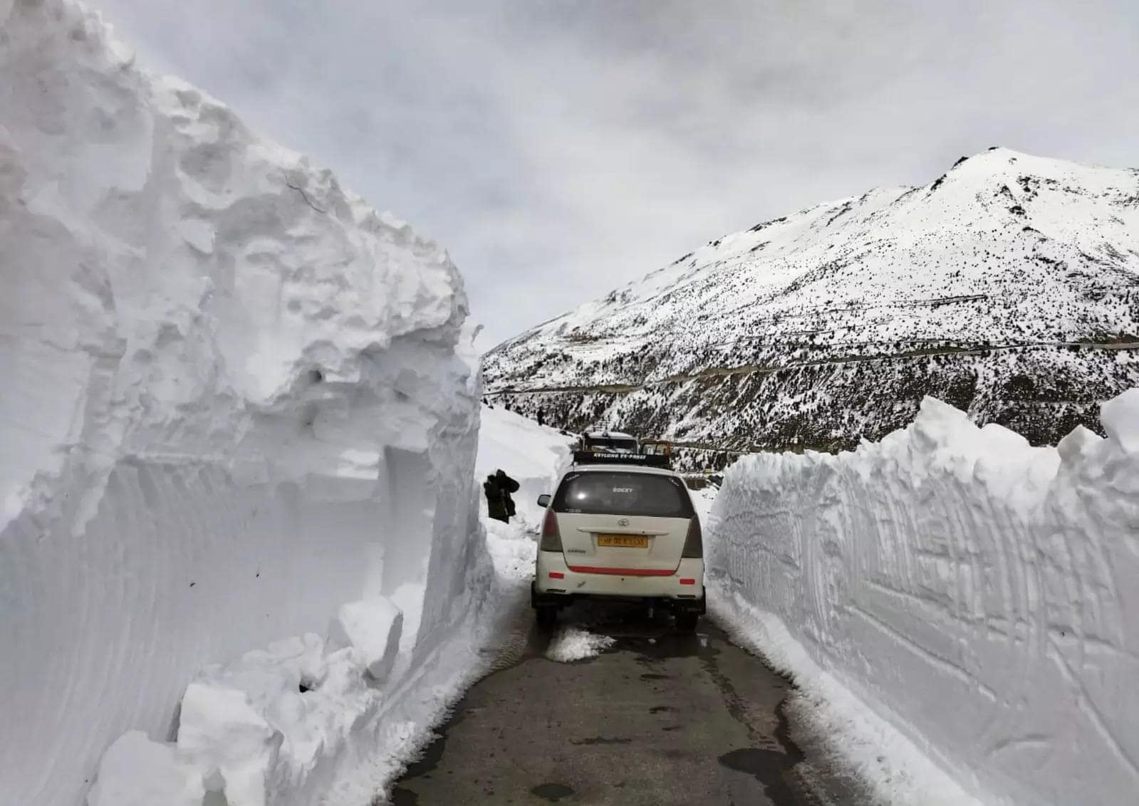 Sarchu region is also well-known as Sir Bhum Chun. Sarchu is on the border between Himachal Pradesh and Jammu and Kashmir States in India. It is a main halt point with tented accommodation in the Himalayas on the Leh-Manali Highway. It is positioned between Baralacha La to the south and Lachulung La to the north, at an elevation of 4,290 m.
The journey along the Manali-Leh highway at high elevation and erratic road conditions, usually takes two days, so travellers and tourists use this spot as an overnight stop. An Indian army camp is sited nearby on the banks of the Tsarap Chu River. The highway and thus the camp are closed during the winter, when snow blocks the high passes along the road.
Sarchu was an essential trading spot in the earliest Silk Route. It is still a most favourite with traders, traveling tribes and adventure seekers. Between May and September, Sarchu becomes the starting point for treks to Zanskar in Ladakh. The route is popular with trekkers and high altitude climbers as one has to deal with hostile conditions and difficult terrain.
Places to Visit in Sarchu
Tsarap River
The source of Tsarap River is in the glaciers at the boundary of Jammu and Kashmir and Himachal Pradesh and close to Pankpo La Pass. After expanding from its source, the Tsarap River runs southwest up to Sarchu, a campsite at the Leh-Manali Highway, here the Tsarap River links a confluent of three rivers of Lingti, Yunan and Sarchu River.
Tsarap River is joined to Kargyag River in Purne village. Kargyag River initiates near Shingo La pass. After combining with Kargyag River the Tsarap River flows downward in the Zanskar valley, throughout of Mone, Tichip, Jamyang Lang, Dorzong and Chia these cities.
Tsarap River is then flowing together with its branches, like Stod River, at Padum region, which is the capital of Zanskar. Together, these two rivers form the Zanskar River, a stream of the Indus River.
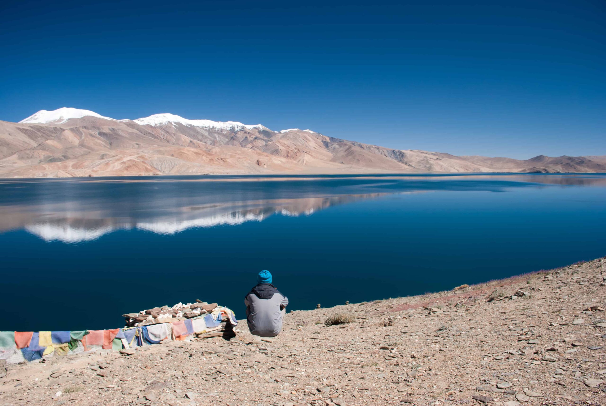 Tso Moriri or Lake Moriri' it is called is a blue sapphire beautiful fresh water lake in the Changthang area of Jammu and Kashmir. Tso Moriri is a less visited haven on earth, habitat to some of the striking animals and birds, this uninhabited place is a nature's jewels trove. This Tso Moriri lake is totally in Indian region and it is one of the largest high altitude lakes at an height( altitude) of about 4,595 m in the Trans-Himalayan biogeography state. The lake sits between Ladakh, India to the North, Tibet to the east and Zanskar in the west.
Tsomoriri Lake Also known as Moriri Lake, Tsomoriri Lake is positioned at an elevation of 15,075 feet and the largest lake in the Ladakh region. It has been declared as a Wetland of International Importance under the Ramsar Convention in 2003. It is fed by two streams and springs. 7 kilometers wide and 19 kilometers long, this stunning blue lake plays host to a huge number of flora and fauna. Adjacent to this lake is a picturesque village known as Korzok, which is a popular tourist attraction due to its Buddhist monastery. This lake plays host to as many as 34 species of birds.
Tsomoriri Lake enclosed springs and melted snow from mountains on the Changthang plateau. Water enters the Tsomoriri Lake in two main flow systems, one flowing towards lake from the north side, another entering in the Tsomoriri Lake from the south-west side. Both the tributary water systems generate far-reaching swamp or marshes from where they go into the lake. It previously had a channel or a passage to the south, but since it is blocked so the lake has become land bared. Due to this, the water of this beautiful lake is now saline or salty.
Places to Visit in Tso Moriri
Korzok Monastery
Korzok Monastery situated in the ancient village, on the western bank of the Tso Moriri Lake, Korzok Monastery is a Tibetan monastery that belongs to the Drukpa Lineage. The monastery is around 400 years old and attracts a large number of Buddhist pilgrims and travelers.
